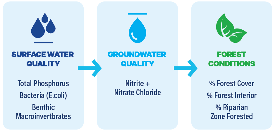
Conservation Authority Watershed Report Cards measure and report on three resource categories: Surface Water Quality, Groundwater Quality and Forest Conditions with a set of indicators for each category.

The conservation authorities chose these three resource categories because they relate to two key Conservation Authority business functions: protecting and enhancing water quality, and preserving and managing natural areas.

As resources permit, some conservation authorities have also reported on wetland conditions within their watersheds. Guidance has been provided to the CAs but it is not a required indicator.

Not each Conservation authority has equal resources to track and analyse local conditions, or have not been collecting data for the same length of time. Conservation authorities indicate on the report cards if there is insufficient or no data available for an indicator.

As well, for the same reason, conservation authorities do not report on forest biodiversity which is an important indicator for the health of forests. The greater the variety of native species for both trees and vegetation, the more resilient a forest and its surrounding area is to climate change impacts such as drought, extreme weather and invasive species.

Some Conservation Authorities have added additional categories, however, standardized criteria and grades have not been developed for these at this time.

The following are the indicators for the three resource categories:

Not each Conservation Authority has equal resources to track and analyse local conditions, or have not been collecting data for the same length of time. Conservation Authorities indicate on the report cards if there is insufficient or no data available for an indicator.

surface water quality icon

Surface Water Quality

Surface water is the water that makes up our rivers, lakes and streams. Conservation Authorities assess the quality of these water bodies by measuring water chemistry (phosphorus, chloride) and organisms that live in the sediment at the bottom of streams and rivers. Some conservation authorities also measure bacteria.

Read More
groundwater quality icon

Groundwater Quality

Groundwater is the water found beneath the earth's surface, in water bearing layers known as aquifers. Groundwater is difficult if not impossible to clean once contaminated, so it is critical to protect areas of groundwater recharge. Conservation Authorities monitor water chemistry (nutrients, metals, chloride & nitrates).

Read More
forest conditions icon

Forest Conditions

Forests provide habitat and shade; they help to clean our air and water and they protect the soil which promotes water infiltration and reduces both erosion and flooding. Forests also help to cool the land and air – nature's air conditioner! Conservation Authorities assess the area of their watersheds covered by forest; and the amount of forest "interior" (areas that are more than 100 meters from the forest edge which provides critical habitat for many species including songbirds.

Read More

Conservation Authority Watershed Report Card Grades

The report cards rely on a letter grading system found in the Guide to Developing Conservation Authority Watershed Report Cards developed by Conservation Ontario and the conservation authorities. This simple grading system makes it easy for readers to assess the healthy of the watershed in general terms.

  •  A - Very healthy watershed conditions
  •  B - Healthy watershed conditions
  •  C - Watershed conditions require improvement
  •  D - Poor watershed conditions require improvement
  •  F - Watershed significantly degrading requiring much improvement